Team

Product 1
 Smart Edge-AI Equipped UAV Inspection System
Our Smart UAV system eliminates slow, risky manual inspections. Autonomous flight with centimeter-level GPS navigation, multi-modal sensors (RGB, thermal, LiDAR), and onboard AI inference provide instant actionable insights. Output includes crack dimensional analysis, contour maps, and georeferenced digital twin models.
Sector
Other
Industry
Other
Model
B2B
SaaS
B2G
Technology
AI / ML
Drones
Robotics
THE PROBLEM
Infrastructure inspection is dangerous, expensive, and slow. Traditional methods using scaffolding or rope access have critical flaws: Safety (falls cause construction deaths), Cost (₹8-11 lakhs for a single bridge inspection), Speed (2-3 months for final reports), and Consistency (human inspectors miss defects in inaccessible areas). Failures like the Morbi bridge collapse (2022, 135 deaths) demonstrate the need for better inspection technology.
THE SOLUTIONAT Bots automates inspection using an AI-powered autonomous UAV. One operator completes setup in 30 minutes. The drone flies pre-programmed paths while onboard AI analyzes imagery in real-time. Flight operations take 2-4 hours. Clients receive preliminary defect maps the same day and final 3D reports within 48 hours.
HOW IT WORKSMission Planning: Software auto-generates optimal flight paths for complete coverage, accounting for no-fly zones and camera angles.
Autonomous Flight: UAV follows routes using RTK-GPS (2-5 cm accuracy). Maintains safe distance while capturing overlapping imagery. Thermal camera detects subsurface issues invisible to RGB sensors.
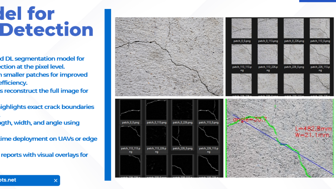
Real-Time AI Analysis: NVIDIA Jetson Orin Nano Super processes images during flight. U-Net++ model performs pixel-level segmentation to identify cracks, spalling, corrosion, and deformation. Calculates defect dimensions using sensor calibration.
Data Synthesis: System stitches thousands of images into 3D point clouds. Each defect tagged with GPS coordinates, dimensions, and severity rating. Generates compliance reports per IS 456/IS 800 structural codes.
- Detection: Crack width from 1.5mm, corrosion, spalling, delamination, rebar exposure
- Sensors: 64MP RGB, 640×512 thermal, LiDAR, 30× optical zoom
- Coverage: 1000-1500 m²/hour
- Accuracy: 2-5 cm horizontal, 5-10 cm vertical (RTK-GPS)
- Range: 3 km radius
- Environment: Wind up to 12 m/s, -10°C to 45°C
- Training: 50,000+ annotated images
- Accuracy: 92% detection rate
- False positives: <8%
- Speed: 15 FPS on Jetson hardware
- PDF Inspection Report (executive summary, defect inventory, repair recommendations)
- Annotated Photo Set with measurement overlays
- 3D Digital Twin (AutoCAD/Revit compatible)
- Raw Data Package (unprocessed imagery and point clouds.
Traditional Inspection (500m bridge):
- Scaffolding + labor + permits + analysis: ₹8-11 lakhs
- Duration: 4-6 weeks
AT Bots Inspection:
- Operator + deployment + analysis: ₹1 lakh
- Duration: 3 days
- Savings: 70-80% cost reduction, 90% time reduction
- Eliminated worker safety risk
- Complete coverage including inaccessible areas
- Real-time data for faster maintenance planning
- Historical tracking for condition trending
India has 1.5 lakh bridges requiring mandatory inspection every 2-5 years per IRC codes. Infrastructure inspection budget exceeded ₹50,000 crore in 2024-25. Current capacity cannot meet demand.
Additional Markets: Building facades, dams, industrial plants (refineries, power stations), historical monuments (ASI conservation).